Tanzania
Tanzania is an East African country known for its vast wilderness areas. They include the plains of Serengeti National Park, a safari mecca populated by the “big five” game (elephant, lion, leopard, buffalo, rhino), and Kilimanjaro National Park, home to Africa’s highest mountain. Offshore lie the tropical islands of Zanzibar, with Arabic influences, and Mafia, with a marine park home to whale sharks and coral reefs
Tanzania is a country renowned for its breathtaking landscapes, abundant wildlife, and rich cultural heritage. It is bordered by Kenya and Uganda to the north, Rwanda, Burundi, and the Democratic Republic of the Congo to the west, and Zambia, Malawi, and Mozambique to the south. To the east lies the Indian Ocean, where the beautiful island of Zanzibar, part of Tanzania, is a popular destination for travelers.
About Tarangire
Considered by many safari aficionados as Tanzania’s best-kept safari secret, the Tarangire National Park was proclaimed in 1970, enlarging the area of its predecessor to incorporate more of the greater Tarangire ecosystem. Tarangire is Tanzania’s 6th largest national park,
It is named for the Tarangire River which runs from south to north through the reserve. ‘Tarangire’ is said to mean “winding river of warthogs” and while these are plentiful, there is much more to the park that makes it a worthwhile destination.
Overlooked by many as one has to detour slightly from the ever-popular Northern Safari Circuit, the Tarangire National Park is a vast haven for species also found in the more popular national. It has several species not found in the other locations, such as the fringe-eared oryx
It receives considerably fewer tourists, meaning that there is generally less congestion at wildlife sightings and visitors experience an enhanced sense of being in the wilderness. Tarangire stands out among its peers thanks to an abundance of two of nature’s giants: African elephants and the peculiar baobab tree. Large predators and typical plains game are numerous throughout the dry season. During the dry season, the perennial Tarangire river is the only reliable water supply, attracting vast herds of game and attendant predators. With the rains, the wildlife disperses and many roads become impassable.
Tarangire Highlights
Bird-watching
A bird lover’s paradise, with over 500 species, including rare endemic species and summer migrants.
Elephants
some 3000 elephants converge on Tarangire during the dry season, with herds up to 300 strong. Excellent sights year-round.
Rock Paintings
Hundreds of these artworks from prehistoric man can be found, particularly in the Kolo district, outside of the park.
Baobab Trees
an abundance of these peculiar ‘upside-down trees’ are found within the park. Visitors can walk inside the “Poacher’s Hide” tree.
Mini-Migration
Tanzania’s second largest migration occurs when wildlife converges on the Tarangire River during the dry season.
Predators
very good sightings of lions, cheetahs, leopards, and spotted hyenas. Also the possibility of highly endangered African wild dogs.
Unusual Species
Fringe-eared Oryx, the rare Coke’s hartebeests, long-necked gerenuk, dik-dik, grant’s gazelles, amongst others.
About Lake Manyara
Lake Manyara National Park, named from the Maasai word “enyara” for the milk-colored water clouded with alkali, is a testament to natural beauty and organic richness. Proclaimed in 1960, the park spans approximately 330 sq. km in northern Tanzania, nestled within the Great Rift Valley.
Its diverse landscape encompasses the alkaline lake, open grasslands, acacia woodlands, and a dense groundwater forest, offering a stunning setting for exploration. The shores, bordered by verdant forests against the backdrop of milky waters and a towering escarpment, provide a haven for wildlife, including the park’s iconic pink flamingos parading in the shallows, attracted by the abundant water sources fed by rivers and streams.
This diversity underscores Lake Manyara’s significance as a rich biodiversity hotspot.
While the park lacks a density of wildlife, it does boast great diversity. Elephants are well-catered for and occur in large herds. Other popular species such as giraffes, zebras, and wildebeest are seldom far from sight. Of the Big 5, only rhinos are absent and the local lions have a peculiar habit of climbing trees. A healthy population of spotted hyenas means that sightings of leopards, cheetahs, and wild dogs are quite rare.
Birdwatchers are spoiled, with over 400 species, while the vegetation is equally fascinating, with ancient fig trees and giant baobabs among the highlights.
Lake Manyara National Park is roughly 126 km (78 mi) from the safari gateway of Arusha, or a 2.5-hour drive. Visitors can also fly directly to the park, which has an airstrip.
Highlights
Varied activities
canoe trips, night drives, and a treetop walkway add variety to your safari activities
Majo Moto kubwa hot springs
Hot water percolates to the surface, creating a fertile swampy habitat that is ideal for nesting birds.
Walking safaris
gain a fresh perspective and appreciation of nature by exploring on foot in the company of an armed guide.
Birdwatching
With an average of over one new specie per square kilometer, bird lovers will have plenty to add to their checklists.
Scenery
The picturesque lake, birdlife, and surrounding landscapes all ooze the best of African scenery.
Tree-climbing lions
This is one of the few places where lions climb trees, presumably to enjoy the breeze and avoid insects.
Elephants
Given their love of water, you are bound to see groups of elephants cavorting in the lake shallows
Year-round safari
The temperate climate and minimal impact of rain mean that visitors can enjoy the wildlife throughout the year.
Ngorongoro Crater
Two million years ago a volcano thought to have been slightly taller than Mt Kilimanjaro erupted with such force that the mouth of the volcano imploded. Once the dust settled, what remained is still the largest intact caldera on earth – the Ngorongoro Crater.
The crater spans 260 km² (100 mi²), with its rim 610 metres (2000 ft) high. An eruption enriched the area with mineral-rich dust, fostering fertile soils. Underground rivers feed springs, bringing nutrients to the surface.
This environment supports permanent water sources, attracting animals. Their presence enriches the soil further, creating a productive grassland. Over time, swamps and forests emerged, hosting the planet’s densest concentration of large mammals.
Ngorongoro Crater, named after the resonant sound of cattle bells once filling its expanse, has evolved from human habitation to a premier wildlife sanctuary. The removal of settlements enabled its transformation into a globally celebrated wildlife haven. It now stands as the core of the Ngorongoro Conservation Area, a World Heritage Site since 1959, lauded for its rich biodiversity and archaeological significance, including the pivotal Olduvai Gorge.
Flanked by the Serengeti and game-controlled zones, it forms a vast conservation mosaic where the Maasai people continue their traditional nomadic life, albeit without cattle grazing within the crater to protect its ecosystem. The crater, a biodiversity hotspot, shelters an estimated 25,000 large mammals.
Highlights
Picnic
There is a picnic area at the Ngoitokitok Springs where visitors can stretch and enjoy a meal.
Game Viewing
With an incredible diversity and abundance of game, visitors are all but assured of great sightings year-round.
Bird-watching
Over 500 species are represented in the overall conservation area, ranging from waterbirds to raptors.
Olduvai Gorge
The site of some of the most significant finds relating to human evolution were made at this site, with a museum and guided tours.
Maasai or Hadzabe Cultural Experience
Guided tours can be arranged to gain insight into the history and traditions of these fascinating cultures.
Hiking
Guided walks on the crater rim and the surrounding landscape of the NCA can be arranged.
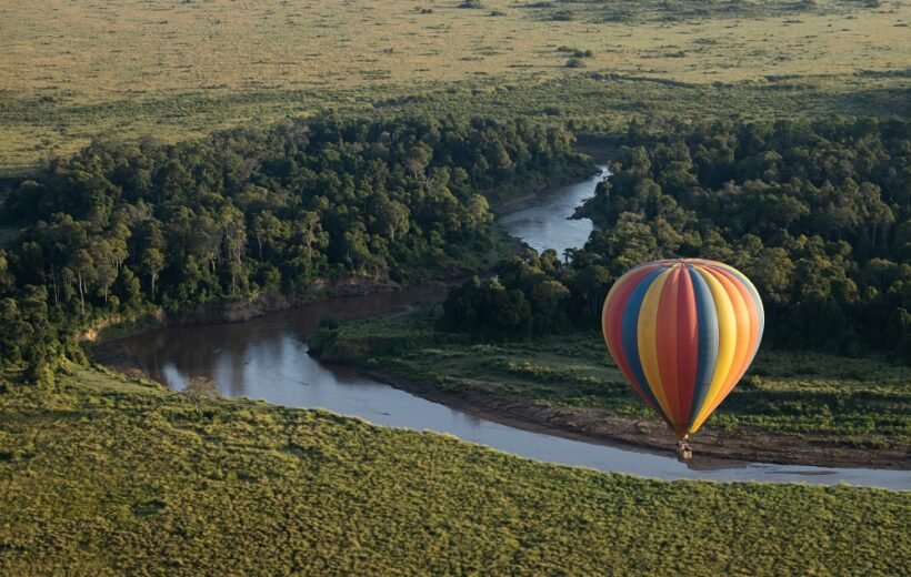
Serengeti National Park
The Serengeti, named by the Maasai, translates to “endless plains” or “the land that runs on forever,” reflecting its vast, unbroken landscapes
Legend has it that the word Serengeti emanates from the people who have occupied this pristine land for aeons–the Maasai. Roughly translated, it means the endless plains, or “the place where the land runs on forever”.
Proclaimed in 1952, and covering 14,763 km2 (5,700 sq mi) – an area larger than Connecticut or Montenegro – in the eastern Mara Region of northern Tanzania, the Serengeti National Park is revered by nature-lovers worldwide as one of the most populous wildlife destinations.
Stretching north to Kenya and bordering Lake Victoria to the West, the diverse habitats within make it the perfect home for creatures great and small. It is also cherished as a World Heritage Site, both for the wildlife it is home to and the abundant relics of prehistoric mankind.
As its name suggests, the overwhelming impression given by the Serengeti is of vast, open spaces dotted with granite kopjes (rock outcrops), flat-topped acacia trees, and undulating grasslands.
Only two permanent rivers pass through the park, although numerous gullies rise in spate when good rains fall.
Closing your eyes, the serenade of Nature soothes the atavistic brain, while her various scents arouse the senses even further.
The near-pristine wilderness aside, Serengeti National Park is most famous for the prolific wildlife that roams the ancient plains. Huge herds of plains game, estimated at some 2 million ungulates, roam the various habitats; grazing, browsing and fertilizing the land they traverse.
The massive herbivorous biomass in turn provides ample hunting opportunities for Africa’s legendary large predators perpetuating the unceasing circle of life and death on the African plains. Here too, visitors are blessed with myriad species of birds and plants–each adding to the awe of nature’s complexity and diversity.
By road, the Serengeti National Park is 335 km (208 mi) from Tanzania’s safari hub, Arusha. By air, seven airstrips service different regions of the park.
Highlights
The Great Migration
the annual migratory circuit of over a million wildebeest and other ungulates, draws predators and tourists alike.
River Crossings
Ungulates run the gauntlet of predators waiting at the rivers they must cross during the migration.
Predators
the abundance of prey means Serengeti boasts the greatest concentration of large predators, including lion, cheetah, leopard, and spotted hyena, on earth.
Pristine Habitats
Careful management of the environment ensures a diversity of habitats; home to innumerable species of fauna and flora.
Excellent Infrastructure
Easily accessible with a vast network of roads, several airstrips and a huge variety of accommodation options.
Retina Hippo Pool
Home to some 200-honking, jostling hippos – a cacophonic sight in central Serengeti, not to be missed.
Bologonja Springs
Seldom visited natural springs that offer both tranquillity and diverse sightings at the water and nearby salt lick.
Moru Kopjes
Your best chance of seeing Serengeti’s heavily protected black rhinos amid the dense bush around the rocky outcrops.
Regions of Serengeti
Central Serengeti (Seronera)
Also known as the Seronera Valley, this region is the location of many of Serengeti’s permanent lodges, and the main airstrip within the park. As such, the volume of tourists (and vehicles) in the area is typically high, particularly in the peak season. This can be a drawback when game viewing. The valley usually teems with wildlife, with herds of zebra, wildebeest, various antelope species, as well as elephants in abundance. This in turn means there is a very good chance of sightings of the park’s large predators – lions, cheetahs and spotted hyenas. The Seronera region is commonly referred to as Africa’s Big Cat Capital and is said to be the best place within Serengeti to spot the elusive leopard. The landscape is a gently undulating acacia ,savanna, where the game is easily viewed. The Great Migration typically moves through this area from April to June and October to December.
Western Corridor and Grumeti
Rated as one of the best places in the Serengeti to view the drama of the Great Migration, the so-called Western Corridor lies within the Kirawira region through which the Grumeti River flows. The river is a key obstacle along the migration route that must be crossed between May and July, to get to better grazing. Not only do the occasionally swift waters carry away the weak, but the river is also home to dozens of huge crocodiles that gorge themselves at this time. Even once across the river, the danger continues as land predators await. Outside the crossing periods, this is a relatively quiet corner of the national park. Various habitats including riverine, floodplains, woodlands and savanna, make up the landscape of this vast valley that leads to Lake Victoria. It is the only place in Serengeti to view colobus monkeys and kongoni antelope, and marked by forests and thickets of dense bush.
Northern Serengeti
Wedged between Seronera and Kenya’s Masai Mara, this area is seldom visited by tourists and is low on infrastructure and service. For those therefore that wish to avoid crowds, this is a region worth the effort to visit. The landscape comprises the rolling grasslands synonymous with Serengeti, and the wildlife is just as abundant, with the migration passing through around June/July, and again from September to November. Dramatic scenes play out on the banks of the Mara River, as the herds make their perilous crossing. The Lobo valley is home to a healthy population of predators, while giraffes, elephants, topi antelope and more criss-cross the landscape. The area is best visited in the dry season, as wildlife tends to disperse with the rains. Bologonja Springs and the nearby salt lick both attract a variety of species at this time
Southern Serengeti
Between December and May, the vast mixed herd of wildebeest, zebra and antelope pauses in its relentless quest for grazing, and the calving season commences on the plains south of Seronera, to the border with the Ngorongoro Conservation Area. Normally in February, the plains resonate with the bleating of thousands of newly born calves, who can walk within minutes and run with the herd within hours. They must strengthen quickly, as when the dry season descends, the mega herd will once again set off in search of grazing to the north. Naturally, the abundance of young means that the predators are on hand, looking for an easy snack–and competition among them is fierce.
Great Migration: World’s Greatest Wildlife Event
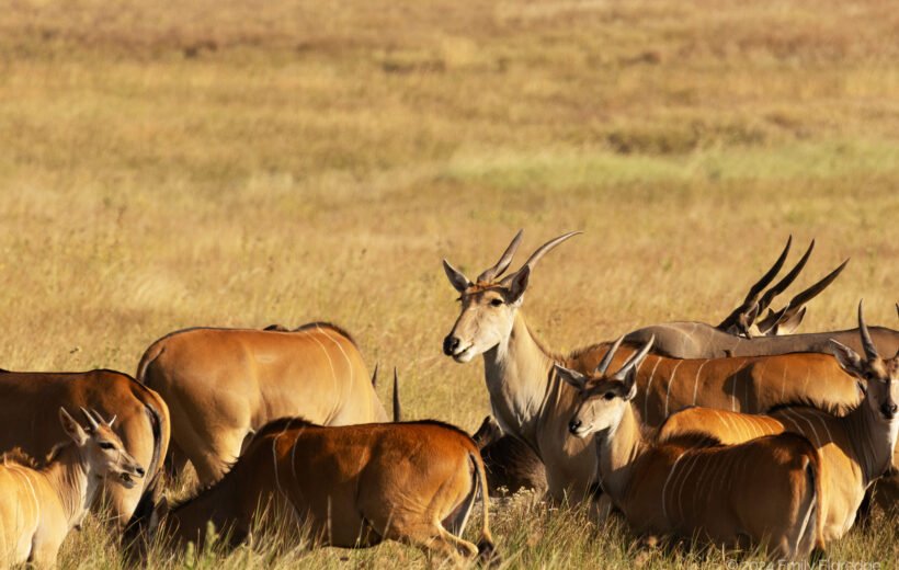
The Great Migration is often called “The Greatest Show on Earth” with good reason. The second largest migration of large mammals on the planet comprises a mixed herd of over a million wildebeest, 400 000 zebras, and a variety of antelope such as eland and Thomson’s gazelle. Outside of the migratory periods, the wildlife disperses to mix with other species of herbivores–such as kudu, impala, giraffe, topi, Cape buffalo, and warthogs, to name a few. In the rivers and water holes, hippos and crocodiles are abundant.
Zanzibar
Zanzibar Archipelago, Including Stone Town
Dive into Zanzibar’s white sands and the historical marvels of Stone Town. Your unforgettable African adventure begins here.
About Zanzibar
Welcome to Zanzibar, Tanzania’s island gem, known for its stunning beaches, rich culture, and historical Stone Town, a UNESCO World Heritage Site. Its warm equatorial climate makes it ideal for beach and water sports enthusiasts.
Explore the island’s heritage through spice tours, enjoy water activities like diving and snorkeling, or relax on a dhow cruise. With a variety of accommodations from luxury resorts to boutique hotels, Zanzibar promises an unforgettable tropical getaway.
Various Regions
Paje Beach
Epitomizing everything expected of a tropical beach – palm trees swaying over sandy beaches fringed by azure waters – Situated on Zanzibar’s east coast, Paje is best known as a base for the colorful kitesurfers that skim across the waves. It also offers excellent SCUBA diving in nearby reefs. There is ample beachside accommodation and several restaurants. Offers safe swimming conditions for supervised children
Nungwi Beach
Rated among the top 25 beaches in the world, part of Nungwi’s appeal is the vibrant nightlife at various establishments along the shoreline. By day, it offers beach lovers good snorkeling, with SCUBA diving also available. Sitting as it does on Zanzibar’s northwest coast, the sunsets are spectacular, best enjoyed aboard a traditional sailing dhow with cocktails flowing. Offers safe swimming conditions for supervised children.
Kizimkazi Beach
Situated on Zanzibar’s south coast, this small fishing community of two villages is best known for its swim-with-dolphin experiences. Please be sure to use only official dolphin guides to ensure an ethical encounter that does not harm the animals. This is not the best swimming beach on the island but snorkeling is rewarding. On land, there are several cultural sites to visit, and a decent selection of accommodation to choose from.
Kendwa Beach
This is a great beach for those who love being in the water, whether swimming, snorkeling or diving. Kendwa is the site of incredible sunsets, for those who want to take the romance to the next level. And, as the sun dips below the horizon, the focus moves from sealife to nightlife, with laid back beach parties rounding off perfect tropical fantasies. The beachfront is well-developed with numerous resorts and restaurants to choose from. Offers safe swimming conditions for supervised children.
Matemwe Beach
This is Zanzibar’s longest beach and can be found on the island’s northeastern coast – with the renowned Mnemba Atoll a short distance offshore. Picture traditional fishing villages shaded by swaying palm trees. It is a great spot for swimming, snorkeling, and diving. Kitesurfing and sailing are also popular here. The beach is generally uncrowded, and you’ll find a handful of hotels and restaurants to choose from. Offers safe swimming conditions for supervised children.
Bwejuu Beach
Best known for romance and relaxation, this long beach lends itself to beach walks along the island’s southeast shore. Aside from the usual beach activities, visitors can take fascinating day trips to the nearby Jozani Forest, or venture over to Stone Town for a fix of authentic Zanzibari culture. Sunset dhow cruises are also popular, before retiring to a beachfront restaurant for a fresh seafood dinner. There is a variety of accommodation to choose from. Bwejuu offers safe swimming conditions for supervised children.
Activities
Cultural Tours
Zanzibar’s history is as colorful and diverse as the tropical landscape of its location. The story of Zanzibar – from past to present – is brought to life in a selection of tours.
Beach
A lounger, a cocktail, lapping waves, a tropical breeze, and fine white sand between your toes. Zanzibar’s beaches are clean, safe, and laid back.
Scuba Diving & Snorkeling
Dip your head below the surface of the warm, crystal clear Indian Ocean and immerse yourself in a pristine otherworldly encounter with abundant marine life.
Cultural Tours
Zanzibar’s history is as colorful and diverse as the tropical landscape of its location. The story of Zanzibar – from past to present – is brought to life in a selection of tours
Spice Tour
Join a sensory journey through fragrant spice plantations and immerse yourself in this rich aspect of Zanzibari history.
Overview of Mt. Kilimanjaro
Rising 5 895 meters (19 341 ft) above the surrounding landscape, Mount Kilimanjaro holds the dual records of being Africa’s highest and the world’s tallest freestanding mountain. With habitats ranging from rainforest to alpine desert, it is an ecologically diverse environment blessed with outstanding scenic beauty. As a non-technical, yet challenging climb, it is easily accessible via the nearby towns of Arusha and Moshi, close to Kilimanjaro International Airport. Whether novice or experienced, seen from its base or the summit, Mount Kilimanjaro promises a rewarding experience equal to the challenge of scaling its weathered, sheer slopes
Marangu Route
Description
Dubbed the “Coca-Cola” route, it is popular with inexperienced climbers who’d prefer to stay in huts than tents. This leads to a false belief that it is easier, when in fact, the short duration allows little time for acclimatisation, and a subsequent low summit success rate. To improve chances, it is recommended to tackle over 6 days.
Landscape
Starting on the southeast of Kilimanjaro, the trail progresses from forest to moors, before taking on a more alien, rugged appearance. The gradient is relatively gentle until the last day, when it gets very steep until the summit. Trekkers use the same path up and down the mountain, limiting the scenery.
Highlights
For some, the sheltered accommodation in huts with cold beverages on offer
Dificulty Level
Difficulty Level Relatively easy until summit day, with lowest success rate.
Distance
Distance 70 km over
5 – 6 Days
Machame Route
Description
Nicknamed the “Whiskey Route”, it is definitely a stiffer challenge than the Marangu Route. However, the extra day or two for acclimatisation to altitude and the ‘climb high, sleep low’ nature of the route makes all the difference and the higher summit success rate is testimony to this. There are some steep sections, but even the fierce-looking Barranco Wall is manageable with the right preparation.
Landscape
Starting in the southwest of the mountain the trek passes through forests, moors and 4 distinct climatic zones to reach the beautiful lunar landscape of the Shira Plateau and famed Lava Tower en route to the summit.
Highlights
Spectacular scenery.
Dificulty Level
Moderately Difficult with 85% success rate
Distance
61 km over 6 – 7 Days
Lemosho Route
Description
Both the most scenic and the most expensive route (due to the longer duration), the Lemosho Route begins west of Kilimanjaro, running parallel to the Shira Route. It then heads across the Shira Plateau and up the Barranco Wall before the challenging summit day to Uhuru Peak. The descent is via the Mweka Route on the south of the mountain.
Landscape
The trail begins with two days of forest trails before heading over moorlands to the Shira Plateau and the spectacular rock formations that follow. With views of distant Mount Meru, it is regarded as possibly the most breath-taking for its diverse scenery.
Highlights
Diverse scenery and high summit success rate, with relatively few people.
Dificulty Level
Moderate difficulty with 90% success rate.
Distance
67 km over 7 – 8 Days
Shira Route
Description
Despite similarities to the Lemosho Route for the latter part of the trek, it eliminates two days spent in the rainforest in favour of a direct steep climb up a 4×4 path, which means you can be driven to the official start at 3500m. So, while it might be shorter, this means that there is inadequate time to get used to the altitude, and this in turn leads to a low success rate amongst climbers. Even those that are acclimatised will need to be confident of their ability.
Landscape
Missing out entirely on the forest and moors at lower altitudes, much of the hike is spent on the starkly beautiful Shira Plateau (from which the route takes its name), before tackling the Barranco Wall and scree slopes en route to the summit.
Highlights
The views of the surrounding landscape below and Mount Meru in the distance. Less people than the Marangu and Machame Routes.
Dificulty Level
Difficult with 80% success rate
Distance
58 km over 6 – 7 Days
Rongai Route
Description
As the only route that starts on the northern side of the mountain, it is drier than all the other routes – and hence, preferred in the Wet Season. While it is less scenic as a result, the trail gradient is sufficiently gradual and the camps nicely spaced, meaning that there is ample time to acclimatise. As fewer people choose this route, it also feels wilder and trekkers may even see some wildlife. From day three, the terrain is gentle if rocky and the shortened stage on the day before summiting is a welcome opportunity to rest before setting off at midnight for the summit. The descent trail follows the Marangu Route to the southeast, taking up to 2 days.
Landscape
The trail begins in the farmlands before passing through the rainforest. This gives way to woodlands, moors and ultimately the alien landscape of the ‘Saddle’. The descent via Marangu entails moors and rainforest once the rocky upper slopes are left behind. Highlights: For most, the scenic location of the campsite in the shadow of the Mawenxi Peak is the most memorable day of the hike (besides the summit, of course).
Dificulty Level
Relatively easy with 85% success rate.
Distance
74 km over 6 – 7 Days
Umbwe Route
Description
The rapid ascent to Barranco Camp in two – as opposed to the usual 3-4 – days, gives trekkers little time to acclimatise to the sharp change in altitude. The trail is steep and exposed, and not for those with a fear of heights. From Barranco, it shares the Machame Route to the summit. Umbwe Route should only be attempted by highly experienced trekkers and using all 7 days.
Landscape
The first two days take trekkers through the rainforest before emerging onto that rock flanks of Kilimanjaro.
Highlights
It is quiet and remote. Reaching Uhuru Peak – only the most experienced climbers do.
Dificulty Level
Very difficult. Experienced climbers only – 70% success rate.
Distance
48 km over 5 – 7 Days
Northern Circuit
Description
Due to its length, the Northern Circuit, extra time for acclimatisation and ‘climb high, sleep low’ routing, trekkers on the Northern Circuit enjoy the highest success rate. The first two days follow the Lemosho Route before veering toward the Lava Tower and around the empty northern flanks of the mountain at around 4000m, until linking up with the Rongai Route which is followed to the summit at Uhuru Peak. The descent follows the Mweka Route, where the abundance of trekkers stands in stark contrast to the solitude at the start of the climb.
Landscape
The first two days pass through rainforest and moorlands before venturing onto the open slopes at altitude.
Highlights
The solitude for much of the route and spectacular views, particularly on the northern slope.
Dificulty Level
Relatively easy but long, with 95% success rate.
Distance
88 km over 8 – 9 Days
Our Tours